


Will there be cyclone by next week? Know what international weather scientists and IMD predict
Bhubaneswar: Undoubtedly, the month of October is prone to cyclone and Odisha almost every year gets affected by such weather activities. The India Meteorological Department (IMD), though, has not issued any warning for cyclone till now, some international weather scientists have predicted that there might be cyclone by next week and it might make landfall either in Odisha or Andhra Pradesh.
According to Jason Nicholls, the International forecasting manager of Accu Weather, a weak low can form over the Arabian Sea the next couple of days and a low will form in the North Bay of Bengal (BoB) early next week which can strengthen to a cyclonic storm before threatening the North Andhra Pradesh and Odisha late next week.
“A weakening low is producing scattered rain in S #India. A weak low can form over the Arabian Sea the next couple of days. A low will form in the N BOB early next week & can strengthen to a CS before threatening the N #AndhraPradesh & #Odisha late next week,” Nicholls said in an X post.
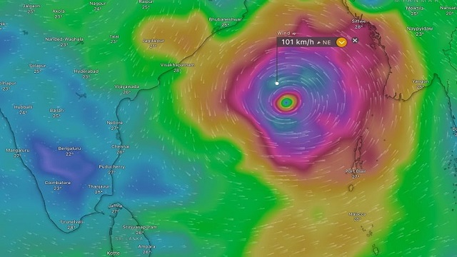
Likewise, the ECMWF and GFS model of the Windy.com, suggests that a depression or cyclone might be formed over the Bay of Bengal between October 22 and October 27 and move towards east India.
While the ECMWF model of the Windy.com shows it might head towards Madhya Pradesh, the GFS suggests that the weather activity is likely to reach Uttar Pradesh or Bihar. However, there is no clarity of the movement of the weather activity so far.
On the other hand, IMD DGM Mrutyunjay Mohapatra while speaking to Kalinga TV today informed that there is no any possibility of cyclone in the next seven days.
“A low pressure area is likely to be formed over the Andaman Sea by October 20. Likewise, another low pressure system is expected to be formed over the central Bay of Bengal (BoB) by October 22 and move towards north-west and gradually intensify into a depression by October 24. However, there is no clarity of it getting further intensified into a cyclone. We are monitoring the system continuously,” Mohapatra said.
From today’s update, all what I can say is that a low pressure system is likely to be formed by October 22 and it might intensify into depression by October 24 and move towards north-west regions. Under the influence of this, Odisha is likely to witness rainfall between October 23 and October 25. Heavy rainfall might lash in some districts.
Meanwhile, the regional centre of the IMD issued the following weather warning:
Day 2 (Valid from 8.30 AM of 18.10.2024 to 8.30 AM of 19.10.2024):
Yellow Warning: Thunderstorm with lightning very likely to occur at isolated places in the districts of Balasore, Bhadrak, Jajpur, Kendrapara, Cuttack, Jagatsinghpur, Puri, Khurda, Nayagarh, Ganjam, Gajapati, Mayurbhanj, Keonjhar, Rayagada, Kalahandi, Nabarangpur, Koraput and Malkangiri.
Day 3 (Valid from 8.30 AM of 19.10.2024 to 8.30 AM of 20.10.2024):
Yellow Warning: Thunderstorm with lightning very likely to occur at isolated places in the districts of Puri, Khurda, Nayagarh, Ganjam, Gajapati, Sonepur, Boudh, Nuapada, Balangir, Kalahandi, Kandhamal, Nabarangpur, Rayagada, Koraput, Malkangiri, Mayurbhanj, Keonjhar, Dhenkanal, Balasore, Bhadrak, Jajpur, Cuttack, Kendrapara and Jagatsinghpur.