


Mocha Intensifies Into ‘Very Severe’ Storm, No Weakening Of System Before Landfall @175Kmph On May 14
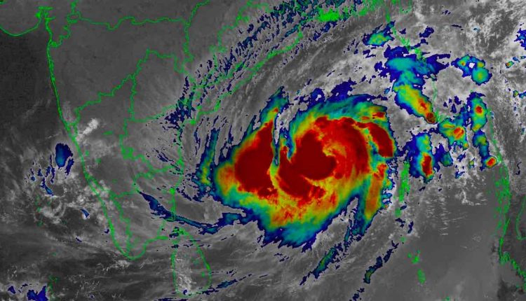
Bhubaneswar: The Severe Cyclonic Storm ‘Mocha’ over Southeast adjoining Central Bay of Bengal intensified into Very Severe Cyclonic Storm (118-220 km/hr) over Central adjoining Southeast Bay of Bengal on Friday morning.
“The Severe Cyclonic Storm over Southeast adjoining Central Bay of Bengal moved northwards with a speed of 9 kmph during past 6 hours, intensified into a Very Severe Cyclonic Storm and lay centered at 5.30 hours over Central adjoining Southeast Bay of Bengal, about 520 km west-northwest of Port Blair, 1010 km south-southwest of Cox’s Bazar (Bangladesh) and 930 km south-southwest of Sittwe (Myanmar),” according to the national bulletin issued by IMD.
The system is unlikely to have a direct bearing on India as it is expected to move towards the Bangladesh-Myanmar coasts.
“It is very likely to move north-northeastwards and intensify further over Eastcentral Bay of Bengal. It is likely to cross southeast Bangladesh and north Myanmar coasts between Cox’s Bazar (Bangladesh) and Kyaukpyu (Myanmar), close to Sittwe (Myanmar) around noon of May 14 as a Very Severe Cyclonic Storm with maximum sustained wind speed of 150-160 kmph gusting to 175 kmph,” it added.
According to the Tropical Weather Outlook, the various numerical models including IMD GFS, NCEP GFS, ECMWF, NCUM, UKMO AND IMD MME are now consistent on the track and landfall point. Current model guidance is not indicating weakening of the system before landfall.
IMD GFS: Landfall around 14/0600 UTC NEAR 20.8N/92.8E
ECMWF: Landfall around 14/0900 UTC NEAR 20.8N/92.2E.
IMD MME: Landfall around 14/0900 UTC NEAR 20.3N/92.8E.
Meanwhile, the US Navy’s Joint Typhoon Warning Centre (JTWC) has also upgraded Mocha to a category 1 cyclone with a forecast peak of at least 120 kt (222 kmph). The recent GFS and ECMWF model runs also show landfall a bit north of JTWC and IMD forecast.
On Thursday, senior meteorologist Jason Nicholls had tweeted that the system has started its turn toward the NE with additional strengthening likely into the weekend. “Landfall as a Very Severe Cyclonic Storm or a Cat 2 or 3 hurricane equivalent is expected between Cox’s Bazar, Bangladesh, and Kyaukpyu, Myanmar, on Sunday,” he added.
According Director of CEC S C Sahu, the system was centered 900 km South of Paradip last night and moved northwards with speed 11 kmph. The favourable sea surface temp 31 degree Celsius may favour further intensification of system till May 13 as the system will recurve northeastwards on May 12 towards Bangladesh coast. He said that there is a probability of cloudy sky on May 12-13 but there is no indication of rain for Odisha.
Though global models are showing north-eastwards movement towards Bangladesh but observational data indicate that landfall maybe in Sunderban-Bangladesh region with wind speed around 200 kmph on May 14 afternoon and in such case, there might be rain in Bhadrak and Balasore, Sahu added.
WIND WARNING
Andaman Islands
Squally wind speed reaching 50-60 kmph gusting to 70 kmph is likely to prevail on May 12.
Tripura, Mizoram & south Manipur
Squally wind speed reaching 50-60 kmph gusting to 70 kmph is very likely to prevail on May 14.
Andaman Sea
Squally wind speed reaching 50-60 kmph gusting to 70 kmph is likely to prevail over North Andaman Sea on May 12.
RAINFALL
Andaman & Nicobar Islands
Rainfall at most places with heavy to very heavy rainfall at isolated places is likely on May 12 and heavy rainfall at isolated places during May 13-14.
Tripura & Mizoram
Rainfall at most places with heavy rainfall at isolated places is likely on May 13 and heavy to very heavy rainfall at isolated places on May 14.
Nagaland, Manipur & south Assam
Rainfall at many places with Heavy rainfall at isolated places on May 14.
Thunderstorm/lightning/gusty winds with light/moderate scattered to fairly widespread rainfall very likely over Kerala & Mahe during next 5 days; over Coastal Andhra Pradesh, South Interior Karnataka and Tamil Nadu, Puducherry & Karaikal on May 12.
FISHERMEN WARNING
Fishermen, ships, boats and trawlers are advised not to venture into central Bay of Bengal and north Andaman Sea till May 14, and into northeast Bay of Bengal during May 12-14. Those over central Bay of Bengal and north Andaman Sea are advised to return to coast.